


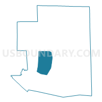
Hampton 1 Voting District, Windham County, Connecticut
About
Outline

Summary
| Unique Area Identifier | 550182 |
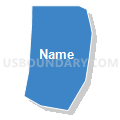
| Name | Hampton 1 Voting District |
| County | Windham County |
| State | Connecticut |
| Area (square miles) | 25.50 |
| Land Area (square miles) | 25.09 |
| Water Area (square miles) | 0.41 |
| % of Land Area | 98.41 |
| % of Water Area | 1.59 |
| Latitude of the Internal Point | 41.78303010 |
| Longtitude of the Internal Point | -72.06457180 |
Maps

Graphs
Select a template below for downloading or customizing gragh for Hampton 1 Voting District, Windham County, Connecticut


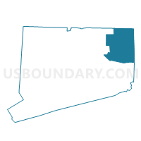
Neighbors
Neighoring Voting District (by Name) Neighboring Voting District on the Map
- Brooklyn 1 Voting District, Windham County, CT
- Canterbury 1 Voting District, Windham County, CT
- Chaplin 1 Voting District, Windham County, CT
- Eastford 1 Voting District, Windham County, CT
- Pomfret 1 Voting District, Windham County, CT
- Scotland 1 Voting District, Windham County, CT
Top 10 Neighboring County Subdivision (by Population) Neighboring County Subdivision on the Map
- Brooklyn town, Windham County, CT (8,210)
- Canterbury town, Windham County, CT (5,132)
- Pomfret town, Windham County, CT (4,247)
- Chaplin town, Windham County, CT (2,305)
- Hampton town, Windham County, CT (1,863)
- Eastford town, Windham County, CT (1,749)
- Scotland town, Windham County, CT (1,726)
Top 10 Neighboring Elementary School District (by Population) Neighboring Elementary School District on the Map
- Brooklyn School District, CT (8,210)
- Canterbury School District, CT (5,132)
- Pomfret School District, CT (4,247)
- Chaplin School District, CT (2,305)
- Hampton School District, CT (1,863)
- Eastford School District, CT (1,749)
- Scotland School District, CT (1,726)
Top 10 Neighboring Secondary School District (by Population) Neighboring Secondary School District on the Map
Top 10 Neighboring State Legislative District Lower Chamber (by Population) Neighboring State Legislative District Lower Chamber on the Map
- State House District 54, CT (28,848)
- State House District 47, CT (24,901)
- State House District 50, CT (24,033)
Top 10 Neighboring State Legislative District Upper Chamber (by Population) Neighboring State Legislative District Upper Chamber on the Map
Top 10 Neighboring 111th Congressional District (by Population) Neighboring 111th Congressional District on the Map
Top 10 Neighboring Census Tract (by Population) Neighboring Census Tract on the Map
- Census Tract 9051, Windham County, CT (8,210)
- Census Tract 9061, Windham County, CT (5,132)
- Census Tract 9025, Windham County, CT (4,247)
- Census Tract 8150, Windham County, CT (2,305)
- Census Tract 8200, Windham County, CT (1,863)
- Census Tract 9022, Windham County, CT (1,749)
- Census Tract 8250, Windham County, CT (1,726)
Top 10 Neighboring 5-Digit ZIP Code Tabulation Area (by Population) Neighboring 5-Digit ZIP Code Tabulation Area on the Map
- 06234, CT (8,244)
- 06331, CT (5,137)
- 06259, CT (4,498)
- 06247, CT (2,841)
- 06235, CT (2,257)
- 06242, CT (1,408)